


Scientists from the British Antarctic Survey (BAS), together with four Chilean research institutes, said the new image analysis and detection method, which involves the use of very high resolution (VHR) satellite images from Maxar Technologies, could help revolutionize how stranded whales -- or those that are dead in the water or beached -- are detected in remote places.
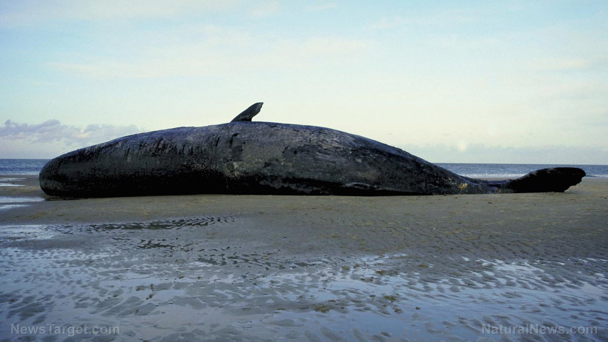
To test this, the scientists used and analyzed archival satellite images from 2015 depicting what was then considered to be the biggest mass stranding of baleen whales to be recorded: the now-infamous sei whale stranding in Chilean Patagonia.
That stranding, as noted in reports from that year, was not discovered for several weeks due to the remoteness of the region, with aerial and boat surveys only assessing the extent of the mortality several months after its discovery.
As it turns out, the body count for that stranding -- 343- was severely underestimated, the scientists said, noting that their analysis revealed the number of dead sei whales (Balaenoptera borealis) to be “nearly double” than the original figure.
"The aerial survey was done on a huge scale and was very impressive, but it's possible some of the carcasses got washed back out to sea in storms and simply weren't counted," Jennifer Jackson, a whale biologist at BAS, said, noting that the number of bodies reported during that time was, at best, only an estimate.

The scientists, in a study published in the journal PLoS ONE, said that the technique, once improved and further developed, could help future researchers and scientists obtain real-time information on stranding events as they happen.
According to Jackson, satellite imaging and analysis can become a useful tool not only because it allows people to obtain real-time information on strandings, but also because it allows local authorities to intervene in strandings, as well as help with conservation efforts.
“The causes of marine mammal strandings are poorly understood and therefore information gathered helps understand how these events may be influenced by overall health, diet, environmental pollution, regional oceanography, social structures and climate change,” Jackson said.
Peter Fretwell, the study’s lead author and a remote sensing specialist at BAS, agreed, noting that using satellite imagery to track and observe whales is a fast and cost-effective alternative to aerial surveys, as it allows researchers and scientists to access and monitor remote areas such as Tasmania, New Zealand, the Falkland Islands and South American Patagonia, all of which are especially prone to cetacean strandings. (Related: North Atlantic right whales “whisper” to protect young calves from predators)
"This is an exciting development in monitoring whales from space. Now we have a higher resolution 'window' on our planet, satellite imagery may be a fast and cost-effective alternative to aerial surveys allowing us to assess the extent of mass whale stranding events, especially in remote and inaccessible areas," Fretwell stated.
Aside from making it easier to track the large baleen whale species, advanced satellite imagery can also make it easier for experts to monitor much smaller whale species, the researchers said.
In addition, according to Carlos Olavarria from the Chilean Center for Advanced Studies in Arid Zones (CEAZA), satellite imaging and monitoring of whales can become a powerful tool to assess the environment and its status, noting in an interview with the BBC that it can help flag potentially deteriorating ocean conditions.
For more stories about the environment and animals, visit Ecology.news.
Sources include:


Please contact us for more information.

