


The greatest danger in a real catastrophe is the desperate hordes of people: This U.S. map reveals which areas to avoid
Monday, December 14, 2015 by: Daniel Barker
Tags: survival planning, population density, zombies
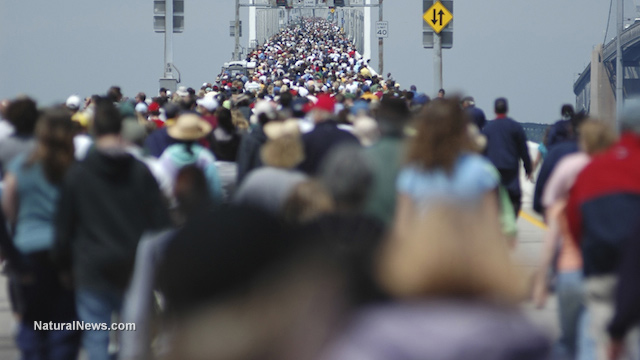
(NaturalNews) Survival experts are generally in agreement about one thing: the biggest danger in a major disaster will not necessarily be the direct effects of whatever the cause is (power grid failure, economic collapse, etc.), but rather the threat posed by millions of desperate people bent on survival at any cost.
Imagine what would happen in major population centers if, for instance, a massive solar flare knocked out the entire power grid of the United States -- a scenario that could easily happen, according to scientists, and one that may be more a case of when rather than if.
Some experts predict that such an outage could take months, or even years, to repair. If that were the case, our large cities would rapidly become unlivable and millions of inhabitants would become desperate, if unwitting, human predators practically overnight.
It's a chilling scenario, but it could happen.
Most survivalists recommend a SHTF preparedness plan that includes what has been termed "strategic retreat" -- in other words, choosing a destination where the chances of survival will be greater. This is typically up to seven miles away from a major highway, a distance considered far enough away to keep hordes of people from disturbing your critical resources.
Do you live in a danger zone?
To help people better plan a strategic retreat, Mac Slavo of SHTFplan.com has posted a map showing the areas of highest population density in the United States. The map, which is based on U.S. census data, shows the most populous counties shaded in blue, so you can easily see which areas to avoid in case of a disaster.Included in this list are counties from coast to coast, ranging from Los Angeles County, California to Bronx County, New York. Franklin County, Ohio and El Paso County, Colorado are also on this list. However, there are many more areas that are heavily populated and as such, more likely to experience huge masses of desperate people running amok and filling the streets with chaos.
It's not just a matter of getting out of an urban area when the SHTF, but also knowing which route to take and where the major highways are located. One thing to consider is the fact that major escape routes from urban centers will likely become hopelessly congested. Areas within a few miles of main highways will also become unsafe.
Recalling history to explain SHTF severity
As Slavo notes:"So, no matter where you are located, consider your proximity to high traffic thoroughfares going in and out of the city. During Hurricane Rita, which hit Houston several years ago, every major pipeline out of the city was jammed for hundreds of miles. Interstate 45 from Houston to Dallas was bumper to bumper traffic. Normally a 4 hour trip, those who didn't evacuate in time were stuck on the highway without food, gas, sanitation, or potable water for upwards of 15 hours."
Cornell University experts study zombies, suggest best place to flee to survive
So, where might the ideal place be to consider as a strategic retreat?According to Cornell University researchers, it's the Rockies.
Interestingly, the researchers studied various stages of disease using a fictional zombie outbreak as a model for their study. Their finding is right in line with those of survivalist experts in that highly-populated areas would be the most dangerous, while fleeing to areas such as the northern Rockies offer the best chances for survival.
"A lot of modern research can be off-putting for people because the techniques are complicated and the systems or models studied lack a strong connection to everyday experiences," says Alex Alemi, a Cornell University graduate student who worked on this study. "Not that zombies are an everyday occurrence, but most people can wrap their [brains] around them."
So, when you begin taking steps to become prepared for a SHTF scenario, be sure to take population density into consideration. Studying a population density map and making plans accordingly could be the key to your survival.
Sources for this article include:
http://www.shtfplan.com
http://www.businessinsider.com
http://www.eurekalert.org


Survival planning at FETCH.news
Get independent news alerts on natural cures, food lab tests, cannabis medicine, science, robotics, drones, privacy and more.

Take Action: Support Natural News by linking to this article from your website
Permalink to this article:
Embed article link: (copy HTML code below):
Reprinting this article:
Non-commercial use OK, cite NaturalNews.com with clickable link.
Follow Natural News on Facebook, Twitter, Google Plus, and Pinterest
- Chemtrails: Learn how to protect yourself from these treacherous poisons
- Flu vaccines causing massive spike in deaths of elderly across the UK, warn health officials
- The Great Culling has begun: Will your genetic lineage survive?
- Gravity water filter scientific test results released by Natural News: Big Berkey, ProPur, Zen Water Systems and more
- The best and worst forms of magnesium to take as a supplement
- Royal Rife: Cancer Cure Genius Silenced by Medical Mafia
- Heal Yourself in 15 Days by Cleaning Up Your Skin Exposure (Part Ten)
- Seven ways to find joy in tough times
- Fox News covers fake blueberries story uncovered by Health Ranger
- Golden rice debunked: ten blatant contradictions and false claims of genetically modified rice
- 12 easy ways to remove acid build-up from your body, alkalize your pH and beat disease
- Green tea extract may help prevent type-2 diabetes through improved glucose tolerance
- Vivid dream: Health Ranger witnesses destruction of a 'Greek island' in America and a government-run cyber warfare false flag attack
- Inflammation is the cause of nearly all disease - Here's how to prevent it
- Ten Natural Ways Grow Hair and Reduce Hair Loss
- Essiac Tea is a Cancer Cure Big Pharma Does Not Want You to Know About
- Indian black salve: The magical cancer cure
- Six natural remedies for lowering blood pressure fast
- Green tea extract may help prevent type-2 diabetes through improved glucose tolerance
- Inflammation is the cause of nearly all disease - Here's how to prevent it
- Chemtrails: Learn how to protect yourself from these treacherous poisons
- HEAL your thyroid: Health Ranger discloses water secrets, iodine science, natural cures and more in the Thyroid Connection Summit
- The best and worst forms of magnesium to take as a supplement
- Antibiotics used in meat pose a threat to public health, admits FDA
- What's really in vaccines? Proof of MSG, formaldehyde, aluminum and mercury
- Beat cancer with 35% hydrogen peroxide
- Toddler injected with 37 vaccines before the age of two left paralyzed and wheelchair-bound for life
- Indian black salve: The magical cancer cure
- Steve Jobs dead at 56, his life ended prematurely by chemotherapy and radiotherapy for cancer
- How laetrile or B17 from apricot seeds kills only cancer cells
- Seven ways to find joy in tough times
- Review: Violet Ray Crystal Resonator machine broadcasts healing energy for your body, mind and home
- Zeolite truths, myths, benefits and exaggerations... explosive interview with zeolite expert blows the lid on what's REAL vs. BOGUS
- Gravity water filter scientific test results released by Natural News: Big Berkey, ProPur, Zen Water Systems and more
- Royal Rife: Cancer Cure Genius Silenced by Medical Mafia
- The Great Culling has begun: Will your genetic lineage survive?
- The best and worst forms of magnesium to take as a supplement
- Vaccine mafia earns 'F' in science: Australian Health Minister utters the most insanely stupid anti-science statement ever recorded... 'no risks in vaccinating children'
- The United Nations 2030 Agenda decoded: It's a blueprint for the global enslavement of humanity under the boot of corporate masters
- Colorado Batman shooting shows obvious signs of being staged
- Vaccinated children have up to 500% more disease than unvaccinated children
- The MMR vaccine, autism connection
- The real vaccine scam is not that they cause autism, but that they don't even work!
- NASA admits to spraying Americans with poisonous chemtrails
- What's really in vaccines? Proof of MSG, formaldehyde, aluminum and mercury
- New NASA research points to possible HAARP connection in Japan earthquake, tsunami
- Beat cancer with 35% hydrogen peroxide
- NASA gives thumbs up to use of colloidal silver as antibiotic in space; FDA has no jurisdiction in high orbit
- Inflammation is the cause of nearly all disease - Here's how to prevent it
- Anti-foaming agent found in Chicken McNuggets
- Reverse and eliminate cataracts naturally without surgery
- Bicarbonate of Soda Used to Cure Stage Four Prostate Cancer
- Flu vaccines causing massive spike in deaths of elderly across the UK, warn health officials
- Apricot Seeds Kill Cancer Cells without Side Effects
- The Coming Gold Revaluation: Strategic Financial Realignment in an Era of Dollar Collapse
- The AI Data Center Wars Have Begun… Farms, Water and Electricity is Stripped from Humans to Power the Machines
- Eleven days before Iran bombed Tel Aviv, my microscope revealed haunting images of EXACTLY what would happen
- Urgent Wake-Up Call: The Coming AI Robot Wars and the Great Human Unity
- The War on Light: How Governments and Big Pharma Keep You Sick By Blocking Healing Photons
- DECENTRALIZED SPIRITUALITY and the true teachings of Christ: Overcoming the censorship, threats and lies of organized religion to truly know God and the Universal Christ
- THE AI RACE IS ALREADY WON: How China’s power dominance (and America’s climate lunacy surrender) secured its victory in the race to AI superintelligence
- Why the U.S. Government May be Seeking to Slaughter 200 Million Americans to Free Up Excess Power for AI Data Centers and the Race to Superintelligence
- Trump's Trojan Horse: How Stablecoins Are Secretly Paving the Way for a CBDC Control Grid – an Interview with Catherine Austin Fitts
- EXCLUSIVE REPORT: The Trump-Putin Meeting in Alaska - A Historic Pivot that Redefined Global Power
- Morphic resonance “remote viewing” reveals iconic Middle East images of stealth bombers, a falcon and a one-horned ram
- 18 MILLION COVID-JABBED Japanese folks shown to have SIGNIFICANTLY HIGHER DEATH RATES during first year after injection with mRNA clot shots
- AI & economic liberty: Will decentralized tech save human autonomy?
- HEALTH SECRETS: How to Instantly Block MSG Toxicity Using Natural Substances (and the secret of Methylene Blue)
- Franken-butter: Startup backed by Bill Gates creates butter from thin air
- BOMBSHELL: Internal Pfizer documents exposed and reveal at least 16 PERCENT of their mRNA vaccine "adverse events" are REPRODUCTIVE DISORDERS
- BOMBSHELL: DNA testing kits are a SCAM to develop ethnic-specific bioweapons
- How a nasal spray vaccine could turn Americans into walking bioweapons this Fall

Science News & Studies

Medicine News and Information

Food News & Studies

Health News & Studies

Herbs News & Information

Pollution News & Studies

Cancer News & Studies

Climate News & Studies

Survival News & Information

Gear News & Information

News covering technology, stocks, hackers, and more


"Big Tech and mainstream media are constantly trying to silence the independent voices that dare to bring you the truth about toxic food ingredients, dangerous medications and the failed, fraudulent science of the profit-driven medical establishment.
Email is one of the best ways to make sure you stay informed, without the censorship of the tech giants (Google, Apple, Facebook, Twitter, YouTube, etc.). Stay informed and you'll even likely learn information that may help save your own life."
–The Health Ranger, Mike Adams